Computer science and computational thinking provide a variety of tools and techniques for facilitating data collection, delivery, processing, and interpretation in application areas like urban informatics and distributed systems. In a spring 2016 computer science course, Data Mechanics for Pervasive Systems and Urban Applications, CS Lecturer and Hariri Institute Director of Research Development, Andrei Lapets, worked with students to apply various techniques and methods to retrieve and derive data sets, implement optimization algorithms, perform analyses, and create visualizations. All the data retrieved or generated for the individual projects were collected within a unifying framework consisting of a shared database and data set provenance tracking conventions. Students then applied tools and methods learned throughout the course to build platforms and applications to analyze data sets dealing with aspects of urban environments.
In total, students produced 18 different projects, and each project was closely linked to the work of the Smart-city Cloud-based Open Platform and Ecosystem (SCOPE). SCOPE is creating a cloud platform that exposes the digital pulse of the city for innovators to develop smart- city services. It is based on a unique new eco-system of stakeholders, technology, organization, and information. Data sets, logistical support and advice for the student projects were provided by both the City of Boston Department of Innovation and Technology and the Massachusetts Department of Transportation (MassDOT) Office of Performance Management and Innovation.
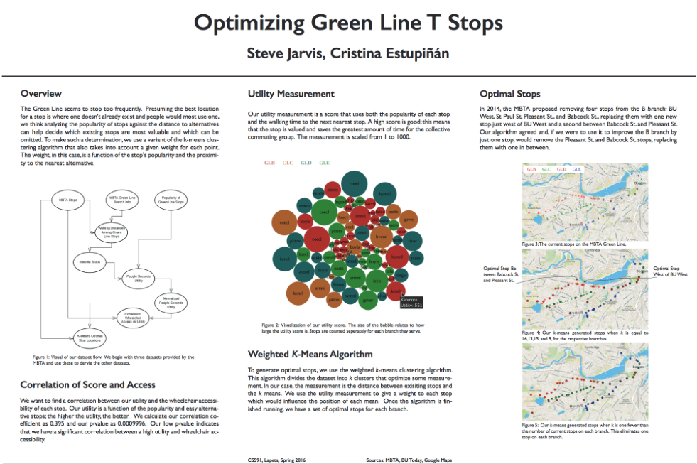
Cristina Estupinan and Steven Jarvis’s project, “Optimizing Green Line T Stops,” highlights how close MBTA train stops are located to one another. Using a variant of the k-means clustering algorithm that takes into account a given weight for each point, the analysis can indicate which of the existing T stops are valuable and which can be omitted.
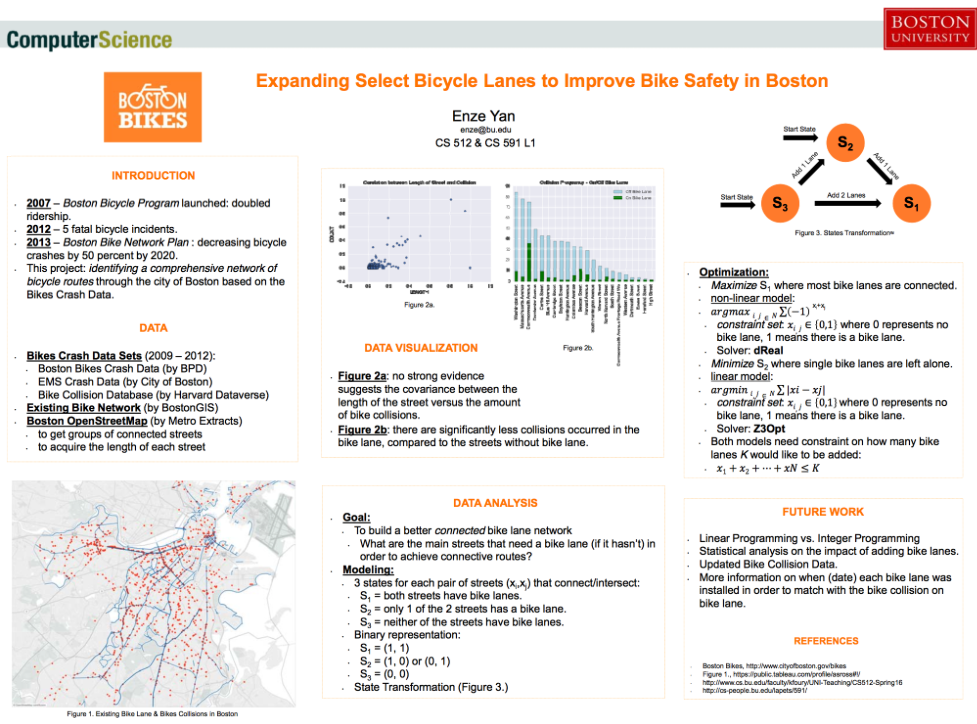
Enze Yan’s project, “Improving Bicycle Route Safety,” aims to build a better connected bike lane network and improve bike safe in Boston. This project explores which main streets need a bike lane to achieve connective routes.
Jacqueline You focused on the aging population in Boston, since census data estimated that by 2030 about 20% of Boston residents will be 60 or older. Her project, “Scoring Age-Friendly Neighborhoods in Boston,” attempts to create a distance-based score for a given location in Boston to quantify its “age-friendliness.” Currently, the distance to the nearest location or the median value in a restricted set of locations is calculated to represent a sub-score for that resource. These sub-scores are then weighted and summed to produce an overall distance-based score.

For a full project listing and access to student reports and additional materials, please visit the course website.
Posted 8 years ago on Friday, June 17th, 2016